Sustaining environments
LI: I am learning to:Describe and compare the characteristics of places in the continents of Australia, South America and Africa.
Describe the location of selected countries in relative terms.
Identify different views on sustaining environments.
Recognise the importance of the environment.
SC: So I can:describe the relative locations of places and countries in different continents
· compare the characteristics of different environments
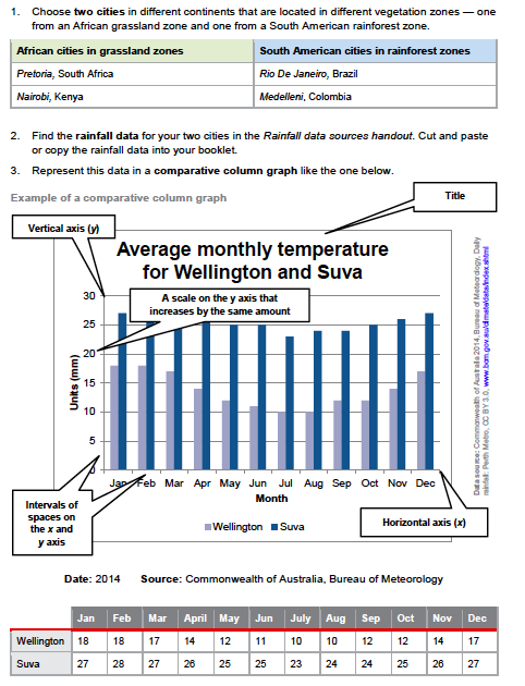
· represent data and information in tables, maps and in a comparative column graph
· interpret data and information to identify patterns, spatial distributions and draw conclusions
· propose actions for sustaining environments.
Describe the location of selected countries in relative terms.
Identify different views on sustaining environments.
Recognise the importance of the environment.
SC: So I can:describe the relative locations of places and countries in different continents
· compare the characteristics of different environments
· represent data and information in tables, maps and in a comparative column graph
· interpret data and information to identify patterns, spatial distributions and draw conclusions
· propose actions for sustaining environments.
Make notes while you watch these videos:
Describing the location of places
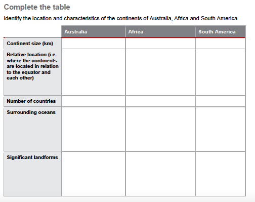
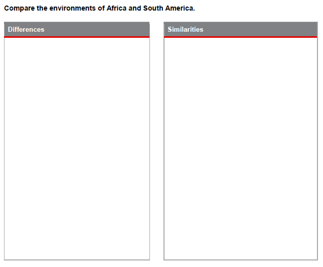
On OneNote Complete the table below to compare the environments in different continents.
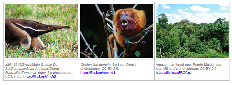
Use an interactive world map and other information sources to record the characteristics of two environments of the continents of Africa and South America.
Use an interactive world map and other information sources to record the characteristics of two environments of the continents of Africa and South America.
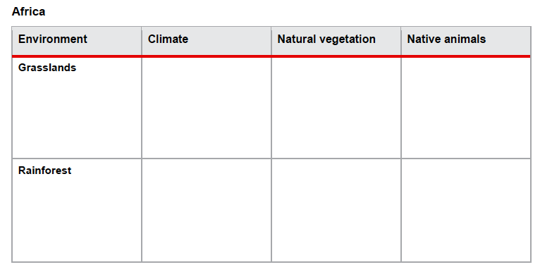
What are the environmental challenges for Africa?
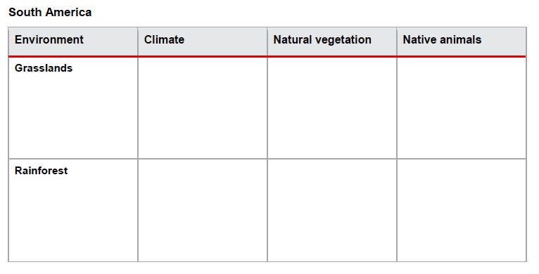
What are the environmental challenges for South America?
Representing data
I am learning to:
Interpret geographical data to identify spatial distributions, simple patterns and draw conclusions.
Propose individual action in response to a geographical challenge and identify the expected effects of the proposed action.
Interpret geographical data to identify spatial distributions, simple patterns and draw conclusions.
Propose individual action in response to a geographical challenge and identify the expected effects of the proposed action.
The World Wide Fund for Nature (WWF) is an international non-government organisation that works on the conservation, research and restoration of the environment.
The following videos produced by WWF provide an overview of environmental challenges and propose individual actions for sustainable living.
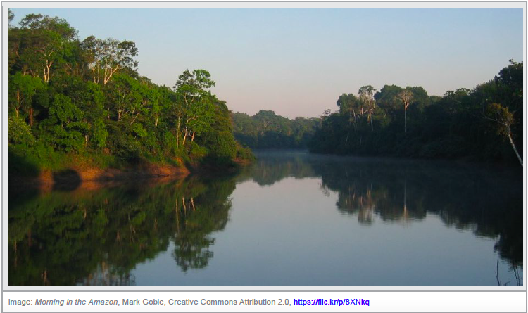
Video 1. The Amazon -‘Identifies the significance of the Amazon as the world’s largest rainforest that is home to one in ten known species on Earth.’
The following videos produced by WWF provide an overview of environmental challenges and propose individual actions for sustainable living.
Video 1. The Amazon -‘Identifies the significance of the Amazon as the world’s largest rainforest that is home to one in ten known species on Earth.’
‘We live on a finite planet and sometimes our impact on it is greater than we realise. This video identifies how individual actions we take every day impact on the world’s environment.’
‘How do we balance the needs of a growing population with a finite planet? This video identifies ways of meeting the challenge of feeding another 2 billion people by the year 2050.’
‘Did you know that the T-shirt on your back has a major impact on the planet? Producing it takes a lot of energy to get it from the cotton fields to your closet. But some of your T-shirt's biggest impacts are in how you care for it. Here's how you can help reduce its effect on the environment.’
‘Do you know what goes into making your laptop? Raw materials for electronic goods are mined from tropical rainforests, but as resources dry up, recycling aluminium is key. This video provides an insight into what our world would be like if more products recycled or reused existing materials.’
I am learning to:
Present findings about sustainability of environments using geographical terminology.
Represent rainfall data in a comparative column graph and the location of places and their characteristics on a large-scale map that uses the cartographic conventions of scale, legend, title and north point.
Present findings about sustainability of environments using geographical terminology.
Represent rainfall data in a comparative column graph and the location of places and their characteristics on a large-scale map that uses the cartographic conventions of scale, legend, title and north point.
Consequences of actions
Choose an environmental challenge, e.g. deforestation or water scarcity.
Complete the table to identify views about how individual people can respond to these challenges.
The environmental challenge is:
Location of places affected-Environmental impacts-Current response-Possible response
Complete the table to identify views about how individual people can respond to these challenges.
The environmental challenge is:
Location of places affected-Environmental impacts-Current response-Possible response
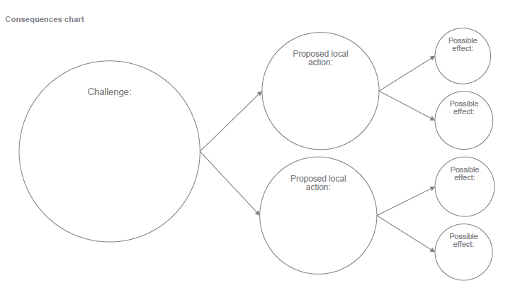
Propose an action that you can take in your life to respond to an environmental challenge.
· Consider the effects of this action.
· Present your findings in a consequence chart.
· Consider the effects of this action.
· Present your findings in a consequence chart.

https://iandslcis.weebly.com/unit-5-sustainability.html
The general capabilities encompass the knowledge, skills, behaviours and dispositions that, together with curriculum content in each learning area and the cross-curriculum priorities, will assist students to live and work successfully in the twenty-first century. They complement the key learning outcomes of the Early Years Learning Framework (COAG 2009) – that children have a strong sense of identity and wellbeing, are connected with and contribute to their world, are confident and involved learners and effective communicators.
The Australian Curriculum includes seven general capabilities:
The Australian Curriculum includes seven general capabilities:
