Term 3
Class Novel
Poetry Unit
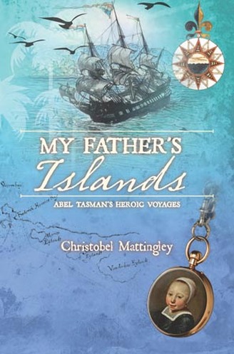
My Father's Islands - Abel Tasman's Heroic Voyages
http://www.nla.gov.au/education/my-fathers-islands/
Award-winning children’s author Christobel Mattingley wrote My Father’s Islands from the perspective of Tasman’s young daughter, Claesgen. While fictitious, the first chapter, ‘Hello! Call me Claesgen’, in which Claesgen introduces herself, will help students connect with a child of an earlier time and place.
Aims of the unitGiven that the time allocated to the unit will vary, at the very least, a study of My Father’s Islands should achieve the following:
Aims of the unitGiven that the time allocated to the unit will vary, at the very least, a study of My Father’s Islands should achieve the following:
- an appreciation of the nature, hardships and achievements of Tasman’s voyages, in relation to maritime exploration of Australia and New Zealand
- the role played by the Dutch in the charting of the coastlines of Australia and New Zealand. (This would provide some balance to the usual emphasis on the role of British maritime explorers, such as James Cook and Matthew Flinders.)
- increased knowledge, through map work, of the geographical landmarks in the Australasian region, including the historical place names formerly used by European explorers and traders.
- an appreciation of the impact on the indigenous peoples who were affected by European exploration and settlement
- empathetic identification with people of another time, through Mattingley’s interpretation of the character of Claesgen and her relationship with her father
- enhanced vocabulary, through compiling a glossary.
Introductory lesson: The portrait of Abel Tasman, his wife and daughterChristobel Mattingley’s inspiration for My Father’s Islands came from a portrait of Abel Tasman with his second wife and his young daughter, painted in 1637 by Jacob Cuyp. The portrait was acquired by the National Library of Australia in 1959.
A copy of the painting is provided in the book, but you could use a large projected image in class by accessing the portrait online at: http://nla.gov.au/nla.pic-an2282370.
Class discussion of this portrait is an excellent starting point for this unit. Any study of the book should at least give time to this.
1. Class discussionWithout saying anything about the portrait, allow the class a few minutes to look at it. Then ask the students for comments or conclusions, or have them record one or two responses on paper. These could form the starting point for discussion.
Questions to stimulate discussion
Conclude this lesson, or start the next one, with Claesgen’s account of having this portrait painted (pp. 32–33).
Suggestions for subsequent lessonsSuggestions for individual, group and/or class activities are set out under chapter headings. For each chapter, there is a short synopsis (in bold italics) to assist you in locating particular content.
This detailed approach will not be suitable if the study of the book has to be curtailed but the suggestions should assist in planning a shorter, but still rewarding, study of My Father’s Islands.
The symbol of a ship indicates chapters that are central to the significance of Tasman’s voyages in the history of Australia and New Zealand, or chapters that could have special appeal to a class.
CHAPTER ONE: Hello! Call me ClaesgenClaesgen introduces herself.
Activities1. Reading aloudRead this chapter to the class.
2. Focus questionWhat was Claesgen’s favourite thing among the gifts her father brought back from his voyages? (Sea shells)
3. Discussion of the relationship between Abel Tasman and ClaesgenWhy do you think Abel Tasman and his daughter were so close?
(Note: While the details of this relationship are imagined by the author, a discussion of this question should help to engage the interest of all students.)
Possible responses:
Claesgen’s mother died when she was a baby and she was a link to Tasman’s first wife.
The long absences of Tasman at sea made their time together more precious.
They shared a curiosity about the world, and Tasman encouraged his daughter to ask questions, while she listened to the stories of his voyages.
They enjoyed laughing together.
4. GlossaryThis could take the form of a class chart, built up during the unit, or it could be compiled by each student, which would suit independent learners. The footnotes provided in the book make compiling such a list a straightforward matter, but the discipline of regularly updating the chart is a sound one. You might need to check spelling, but this could be done quickly as a class activity.
Possible glossary items: sounding (p. 10); burghers, landlubber (p. 11); Terra Australis Incognita (p. 12); mizzen mast, foremast, mainmast (p. 13); astrolabe, cross-staff, sand-glass (p. 14)
5. List of dangers faced by seventeenth-century European explorersThis could be the start of a cumulative list and could provide the basis of a group poster as a follow-up project.
Possible inclusions: storms, reefs, shoals, pirates (p. 11); hostility of other European powers e.g. rivalry with Spain (p. 15)
6. Map workThe maps within the text will be useful for reference, but a map of the world and/or a globe would enable students to identify Holland, and to note its distance from the Dutch East Indies (Indonesia) and Batavia (Jakarta). The journey by sailing ship made such voyages lengthy and sometimes dangerous undertakings.
Have students, in small groups or individually, create a cumulative wall display.
CHAPTER TWO: From cows and canals to captainTasman’s early life; the Dutch East India Company
Activities1. Focus questionWhen, where and why did Abel Tasman achieve his dream of commanding his own ship? (incident, see p. 24)
2. List of dangers faced by seventeenth-century European explorersHave students add this incident to the list of dangers faced by seventeenth-century European explorers.
3. Map workHave students add the following places to the map: Arabia, India, Sumatra, Banda, Ceylon (Sri Lanka), Amboina (Ambon), the Spice Islands (Moluccas), Siam (Thailand), Ceram (Seram).
4. GlossaryAdd: rigging, capstan (p. 19); shrouds (p. 20); caulking, spars (p. 23); pinnace (p. 24)
5. List of spicesMake a list of the spices and luxury goods the Dutch East India Company ships brought back to Europe from the East (see pp. 21–22).
You could do this as a board exercise, with students recording the list in their own notes. This could form the basis of a future project on spices and the spice trade.
CHAPTER THREE: Smugglers, blockades and a portraitTasman returns to Holland, a portrait is painted; Tasman returns to Batavia, accompanied by his wife and daughter.
Activities1. Focus questionHow long did it take to sail from Holland to Batavia, and what was the name of the ship in which Claesgen accompanied her father and stepmother?
(seven months; the Engel(Angel))
2. List of dangers faced by seventeenth-century European explorersAdd: smugglers (p. 30); seamen’s poor diet, causing disease (p. 31); storms (p. 35)
3. GlossaryAdd: astern (p. 34)
4. Creative responseFor project work, have students use the description of the full moon on the ocean on p. 35 to create a painting or some other piece of art.
CHAPTER FOUR: Gold and silver islandsTwo Dutch ships search without success for fabled gold and silver islands. Many sailors die through lack of food. But inaccurate charts are greatly improved for future voyages.
Activities1. Focus questionsWhy were the two ships of the Dutch East India Company sent on this voyage?
Tasman brought his daughter Claesgen a ‘didapper feather’. What is a didapper?
2. Map workIndicate Japan and Formosa (Taiwan) on the map. Using Tasman’s own chart (p. 38), you could have students add the two small islands named after the expedition’s ships.
3. List of dangers faced by seventeenth-century European explorersAdd: Fables and legends led ships on unknown routes, where charts were inaccurate (p. 42); poor diet, bad weather and exhaustion meant many sailors died and were buried at sea (p. 45).
4. GlossaryAdd: longitude, latitude (p. 40); guilder (p. 41); dogwatch (p. 45)
CHAPTER FIVE: To the Unknown South LandTasman’s expedition of 1642
Activities1. Focus questionWhat were the names of the two Dutch ships that Tasman led on this expedition?
(Heemskerck and Zeehaan)
2. Map workPinpoint the island of Mauritius, in the Indian Ocean. (Why did the expedition call there?)
3. List of dangers faced by seventeenth-century European explorersAdd: ships ran aground or broke spars and rigging (p. 57), which often had to be repaired on land (p. 54); ropes and rigging were sometimes old and rotten (p. 55); injuries to sailors had to be treated by the ship’s surgeon (p. 56)
4. GlossaryAdd: steersman, cartographer (p. 51); ‘blew a topgallant gale’, spritsail yard, lying-to (p. 55); boatswain, pitch (p. 56)
CHAPTER SIX: The long watchThe expedition makes a long dangerous journey east across the southern ocean, in search of the Unknown South Land. Land is sighted at last.
Activities1. Focus questionsWhat types of bad weather did the ships and their crews experience in the wild southern oceans?
What sea creatures were seen on this part of the voyage? (Seal, whales, tunny fish)
2. Map workAdd Van Diemen’s Land (Tasmania), New Holland (Australia). You could also indicate the route from Batavia to Mauritius to Van Diemen’s Land (see larger map on pp. 26–27).
3. List of dangers faced by seventeenth-century European explorersAdd: danger of shipwreck in unknown, uncharted seas (p. 62); terrible weather: storms, snow, sleet, hail, fog; long weeks at sea, not knowing when they would see land again. (They left Mauritius on 8 October, 1642. Land sighted (Van Diemen’s Land) on 24 November. How many weeks was this?)
4. GlossaryAdd: coffer (p. 59); top yard, piece of eight (p. 62); ship’s log, quarterdeck (p. 63); poop deck (p. 66); leviathan, lodestone (p. 67).
CHAPTER SEVEN: Van Diemen’s LandThe first sighting of land after 48 days at sea; Tasman names the land Van Diemen’s Land, for the Governor of Batavia; shore party fails to secure fresh food or water; Tasman deduces the natives are giants; the Dutch flag is hoisted in Frederick Henricx Bay.
Activities1. Focus questionAs it was too dangerous to take the small boats ashore through the waves, how was the Dutch flag finally planted in Van Diemen’s Land? What did this symbolise for the Dutchmen?(pp. 79–80)
2. Map workStudents could make a detailed map, labelling the parts of Van Diemen’s Land that Tasman named, as well as Frederick Henricx Bay (now Blackman Bay (p. 79)), where the Dutch flag was raised.
3. List of dangers faced by seventeenth-century European explorersAdd: It was often difficult and dangerous to land and get supplies of fresh food and water (pp. 75–77)
Why did Tasman conclude that the unseen people were very tall, like giants? (p. 77) Was this supposition correct? (No, but it shows that the Europeans expected danger from wild animals and hostile natives (p. 75).
4. Planting the flagThe planting of the flag could be examined further, either at this point in the unit, or later, as a project.
When the First Fleet landed in Sydney Cove in 1788 Captain Arthur Phillip also raised the British flag and a toast was drunk to the new colony.
When the American astronauts landed on the Moon on 20 July 1969, they planted the American ‘Stars and Stripes’. How does this compare with what Tasman did in 1642? (The class could look up this event online and find a photo of the American flag planted on the moon’s surface. One of many relevant sites is:http://www.kidport.com/REFLIB/Science/MoonLanding/MoonLanding.htm
CHAPTER EIGHT: The Tasman Sea and second landfallThe South Island of Staten Landt (New Zealand) is sighted. The seamen relax in calm weather. The ships are approached by native canoes. An anxious night, as the Dutch anticipate hostility.
Activities1. Focus questionWhat souvenirs did Tasman bring Claesgen of things crafted by the Dutch sailors in still weather? (These things were made in calm weather, when the sailors had rare time to relax.)
2. Map workA map of Tasman’s contact with New Zealand might be of particular interest to New Zealand schools.
Maria and Schouten islands are mentioned in this chapter; also Vanderlijns Island (Freycinet Peninsula today) (p. 83); South Island of New Zealand (p. 84).
3. List of dangers faced by seventeenth-century European explorersAdd: Natives in canoes approached the Dutch ships—they could not communicate through language and the sailors feared that they were hostile; Tasman ordered guns in place; night watch was nervous (pp. 85–87)
4. GlossaryAdd: hardtack, prow (p. 85)
CHAPTER NINE: Murderers BayThe Dutch sailors are attacked by natives in canoes, four are killed; Tasman calls the place Murderers Bay.
Activities1. Focus QuestionWhat was distinctive about the hairstyle of the attacking natives? (p. 91)
2. Map workAdd Murderers Bay (Golden Bay), Staten Landt (New Zealand) (p. 95); Abel Tasman Passage (Tasman Sea) (p. 96).
3. List of dangers faced by seventeenth-century European explorersAdd: European seamen were sometimes killed by hostile indigenous peoples, as in the incident at Murderers Bay
Discuss the reasons for hostility: lack of understanding of what was said on both sides, defence of territory by indigenous peoples, perhaps previous bad treatment by sailors on visiting ships
4. GlossaryAdd: quartermaster (p. 92)
CHAPTER TEN: The long sail for water and foodDiscovery The North Island of New Zealand is discovered; coastline makes it too dangerous to land for fresh water.
Activities1. Focus questionHow did the sailors celebrate Christmas Day, 1642? (see p. 101)
2. Map workAdd: Zeehaansbocht, Zeehaan’s Bay (Cook Strait) (p. 99); North Island; Drie Coningen (Three Kings Islands) (p. 103)
3. List of dangers faced by seventeenth-century European explorersAdd: unknown dangerous coastlines, poor weather, often made obtaining fresh food and water difficult (pp. 101–102).
CHAPTER ELEVEN: Finally a welcomePeople of the Tongan Islands trade with the ships’ crews for fresh food; however, water is still not available.
Activities1. Focus questionsHow did the Dutch sailors trade with the islanders?
How did they ‘pay’ for the food the local people brought to the ship? (pp. 107–108)
2. Map workAdd: Tongan Islands
3. List of dangers faced by seventeenth-century European explorersAdd: fear of hostile encounters because of the loss of men at Murderers Bay (pp. 108, 110, 111)
4. DiscussionSee the drawings of this encounter made by the expedition’s draughtsman, Mr Gilsemans (pp. 106, 115, 116–117).
CHAPTER TWELVE: Adrift!A shore party manages to obtain water; the Heemskerck breaks away from its anchorage and starts to drift
Activity1. Focus questionsWhat caused the ship to start drifting?
How would the shore party have felt when they saw their ship was not there? (p. 120)
(The steep bottom to the bay, afternoon trade wind meant the ship’s anchor broke free. The crew was reduced because of the shore party, so it had trouble securing the vessel, which continued to drift. The class could reflect on how critical it was not to lose touch with the ship!)
CHAPTER THIRTEEN: Water at last!The two ships get back together; a good supply of water for the expedition is obtained from another Tongan island; they sail past Fiji; storms and wild weather hit the ships
Activities1. Focus questionWhat did Tasman particularly enjoy about a rare expedition ashore on one of the Tongan islands?
(The scent of the earth and flowers p. 128.)
2. List of dangers faced by seventeenth-century European explorersAdd risks to ships on such expeditions:
4. GlossaryAdd: leeward (p. 123); a lee shore (p. 129); hogshead (p. 125)
5. Map workAdd: Prins William Eylanden (Fiji) (p. 130)
CHAPTER FOURTEEN: ‘Dark, rough, and dirty weather …’Vivid description of sailing north and west in monsoon conditions—six weeks without seeing the sun; sightings of more islands, natives; barter attempts yield little
Activities1. Focus questionWhat did the quartermaster of the Heemskerck give away in an attempt to trade with the native people?(p. 141)
2. List of dangers faced by seventeenth-century European explorersAdd: long weeks of wet weather affected the mood of the sailors (pp. 136–137).
3. Map workAdd: Nova Guinea (New Guinea), New Ireland, Solomon Islands
CHAPTER FIFTEEN: Calms, currents, earthquakes and encountersThe ships search for a shorter passage back to Batavia along New Guinea coast; they experience an earthquake at sea and sail past a glowing volcano
Activity1. Focus questionHow did the earthquake at sea affect the ships? (p. 147)
CHAPTER SIXTEEN: Coconuts, coconuts and more coconutsThe ships barter with the native people for huge piles of coconuts
Activity1. Focus questionWhat was Claesgen’s concern about all the trade with the natives in coconuts?
(If there is time, this could be the basis of a discussion about what value the visiting ships were to the native peoples: were they treated justly by the visiting sailors?)
CHAPTER SEVENTEEN: ‘So many large and small islands that there is no counting them’The voyage continues along the New Guinea Coast; good passage is discovered for ships going west from Batavia to Peru; death of the Zeehan’s Captain; the homecoming, after 10 months at sea
Activity1. Focus questionWhat two losses occurred on 5 June? (p. 162: the kedge anchor, and a sailor charged with wrong doing, who swam to an island)
CHAPTER EIGHTEEN: ‘We kept doing our best’Abel Tasman receives a warm welcome from his family, but the Council of India is lukewarm about his great achievement: few prospects for trade and profit, ‘not adventurous enough’
Activity1. Focus questionsWhy was Claesgen so upset after her father returned from seeing the Council of India, which had sponsored the trip?
What point does Tasman’s wife, Jannetje, make about the achievement of the voyage? (‘sailed further south than any previous navigator had done’ (p. 167))
For further information on Tasman’s achievements, see p 180.
CHAPTER NINETEEN: My father’s special islandIn this final chapter the author imagines a conversation between Abel Tasman and his young daughter (For classes that have been able to undertake an in-depth study, this provides a delightful conclusion to the story.)
Activities1. Reading aloudAn ideal chapter to read aloud to the class.
2. Focus questionWhy don’t the names of Tasman’s wife and daughter appear on any maps? (p. 173) (Talk about the special small group of islands that Tasman perhaps secretly named for his family.)
TASMAN’S LATER YEARS
A copy of the painting is provided in the book, but you could use a large projected image in class by accessing the portrait online at: http://nla.gov.au/nla.pic-an2282370.
Class discussion of this portrait is an excellent starting point for this unit. Any study of the book should at least give time to this.
1. Class discussionWithout saying anything about the portrait, allow the class a few minutes to look at it. Then ask the students for comments or conclusions, or have them record one or two responses on paper. These could form the starting point for discussion.
Questions to stimulate discussion
- What clues tell you that this portrait was painted a long time ago? (Before photography and cameras, clothes the subjects are wearing etc.)
- Why did people have portraits painted? (Before photography, for their families, to honour someone for their achievements etc.).
- Who do you think the people in this portrait might be? How does the artist arrange the family? What does this suggest? (The prominent position of the man—is he someone important? The woman? The child? How old do you think the girl is?)
- Are the people related? (Why do you think this?)
- Do you think the people shown are rich or poor? Give reasons. (How the people are dressed: fabrics, stiff white collars, dark colours. Would they have worn clothes like this every day? What are the woman and the little girl wearing on their heads?)
- What do you think the man’s occupation might be? (Clue in the globe--direct attention to it if necessary.)
- What is the woman holding in her hand? Do you think the artist might have asked her to hold this for a special reason?
- Would having a portrait painted be tedious for a child?
Conclude this lesson, or start the next one, with Claesgen’s account of having this portrait painted (pp. 32–33).
Suggestions for subsequent lessonsSuggestions for individual, group and/or class activities are set out under chapter headings. For each chapter, there is a short synopsis (in bold italics) to assist you in locating particular content.
This detailed approach will not be suitable if the study of the book has to be curtailed but the suggestions should assist in planning a shorter, but still rewarding, study of My Father’s Islands.
The symbol of a ship indicates chapters that are central to the significance of Tasman’s voyages in the history of Australia and New Zealand, or chapters that could have special appeal to a class.
CHAPTER ONE: Hello! Call me ClaesgenClaesgen introduces herself.
Activities1. Reading aloudRead this chapter to the class.
2. Focus questionWhat was Claesgen’s favourite thing among the gifts her father brought back from his voyages? (Sea shells)
3. Discussion of the relationship between Abel Tasman and ClaesgenWhy do you think Abel Tasman and his daughter were so close?
(Note: While the details of this relationship are imagined by the author, a discussion of this question should help to engage the interest of all students.)
Possible responses:
Claesgen’s mother died when she was a baby and she was a link to Tasman’s first wife.
The long absences of Tasman at sea made their time together more precious.
They shared a curiosity about the world, and Tasman encouraged his daughter to ask questions, while she listened to the stories of his voyages.
They enjoyed laughing together.
4. GlossaryThis could take the form of a class chart, built up during the unit, or it could be compiled by each student, which would suit independent learners. The footnotes provided in the book make compiling such a list a straightforward matter, but the discipline of regularly updating the chart is a sound one. You might need to check spelling, but this could be done quickly as a class activity.
Possible glossary items: sounding (p. 10); burghers, landlubber (p. 11); Terra Australis Incognita (p. 12); mizzen mast, foremast, mainmast (p. 13); astrolabe, cross-staff, sand-glass (p. 14)
5. List of dangers faced by seventeenth-century European explorersThis could be the start of a cumulative list and could provide the basis of a group poster as a follow-up project.
Possible inclusions: storms, reefs, shoals, pirates (p. 11); hostility of other European powers e.g. rivalry with Spain (p. 15)
6. Map workThe maps within the text will be useful for reference, but a map of the world and/or a globe would enable students to identify Holland, and to note its distance from the Dutch East Indies (Indonesia) and Batavia (Jakarta). The journey by sailing ship made such voyages lengthy and sometimes dangerous undertakings.
Have students, in small groups or individually, create a cumulative wall display.
CHAPTER TWO: From cows and canals to captainTasman’s early life; the Dutch East India Company
Activities1. Focus questionWhen, where and why did Abel Tasman achieve his dream of commanding his own ship? (incident, see p. 24)
2. List of dangers faced by seventeenth-century European explorersHave students add this incident to the list of dangers faced by seventeenth-century European explorers.
3. Map workHave students add the following places to the map: Arabia, India, Sumatra, Banda, Ceylon (Sri Lanka), Amboina (Ambon), the Spice Islands (Moluccas), Siam (Thailand), Ceram (Seram).
4. GlossaryAdd: rigging, capstan (p. 19); shrouds (p. 20); caulking, spars (p. 23); pinnace (p. 24)
5. List of spicesMake a list of the spices and luxury goods the Dutch East India Company ships brought back to Europe from the East (see pp. 21–22).
You could do this as a board exercise, with students recording the list in their own notes. This could form the basis of a future project on spices and the spice trade.
CHAPTER THREE: Smugglers, blockades and a portraitTasman returns to Holland, a portrait is painted; Tasman returns to Batavia, accompanied by his wife and daughter.
Activities1. Focus questionHow long did it take to sail from Holland to Batavia, and what was the name of the ship in which Claesgen accompanied her father and stepmother?
(seven months; the Engel(Angel))
2. List of dangers faced by seventeenth-century European explorersAdd: smugglers (p. 30); seamen’s poor diet, causing disease (p. 31); storms (p. 35)
3. GlossaryAdd: astern (p. 34)
4. Creative responseFor project work, have students use the description of the full moon on the ocean on p. 35 to create a painting or some other piece of art.
CHAPTER FOUR: Gold and silver islandsTwo Dutch ships search without success for fabled gold and silver islands. Many sailors die through lack of food. But inaccurate charts are greatly improved for future voyages.
Activities1. Focus questionsWhy were the two ships of the Dutch East India Company sent on this voyage?
Tasman brought his daughter Claesgen a ‘didapper feather’. What is a didapper?
2. Map workIndicate Japan and Formosa (Taiwan) on the map. Using Tasman’s own chart (p. 38), you could have students add the two small islands named after the expedition’s ships.
3. List of dangers faced by seventeenth-century European explorersAdd: Fables and legends led ships on unknown routes, where charts were inaccurate (p. 42); poor diet, bad weather and exhaustion meant many sailors died and were buried at sea (p. 45).
4. GlossaryAdd: longitude, latitude (p. 40); guilder (p. 41); dogwatch (p. 45)
CHAPTER FIVE: To the Unknown South LandTasman’s expedition of 1642
Activities1. Focus questionWhat were the names of the two Dutch ships that Tasman led on this expedition?
(Heemskerck and Zeehaan)
2. Map workPinpoint the island of Mauritius, in the Indian Ocean. (Why did the expedition call there?)
3. List of dangers faced by seventeenth-century European explorersAdd: ships ran aground or broke spars and rigging (p. 57), which often had to be repaired on land (p. 54); ropes and rigging were sometimes old and rotten (p. 55); injuries to sailors had to be treated by the ship’s surgeon (p. 56)
4. GlossaryAdd: steersman, cartographer (p. 51); ‘blew a topgallant gale’, spritsail yard, lying-to (p. 55); boatswain, pitch (p. 56)
CHAPTER SIX: The long watchThe expedition makes a long dangerous journey east across the southern ocean, in search of the Unknown South Land. Land is sighted at last.
Activities1. Focus questionsWhat types of bad weather did the ships and their crews experience in the wild southern oceans?
What sea creatures were seen on this part of the voyage? (Seal, whales, tunny fish)
2. Map workAdd Van Diemen’s Land (Tasmania), New Holland (Australia). You could also indicate the route from Batavia to Mauritius to Van Diemen’s Land (see larger map on pp. 26–27).
3. List of dangers faced by seventeenth-century European explorersAdd: danger of shipwreck in unknown, uncharted seas (p. 62); terrible weather: storms, snow, sleet, hail, fog; long weeks at sea, not knowing when they would see land again. (They left Mauritius on 8 October, 1642. Land sighted (Van Diemen’s Land) on 24 November. How many weeks was this?)
4. GlossaryAdd: coffer (p. 59); top yard, piece of eight (p. 62); ship’s log, quarterdeck (p. 63); poop deck (p. 66); leviathan, lodestone (p. 67).
CHAPTER SEVEN: Van Diemen’s LandThe first sighting of land after 48 days at sea; Tasman names the land Van Diemen’s Land, for the Governor of Batavia; shore party fails to secure fresh food or water; Tasman deduces the natives are giants; the Dutch flag is hoisted in Frederick Henricx Bay.
Activities1. Focus questionAs it was too dangerous to take the small boats ashore through the waves, how was the Dutch flag finally planted in Van Diemen’s Land? What did this symbolise for the Dutchmen?(pp. 79–80)
2. Map workStudents could make a detailed map, labelling the parts of Van Diemen’s Land that Tasman named, as well as Frederick Henricx Bay (now Blackman Bay (p. 79)), where the Dutch flag was raised.
3. List of dangers faced by seventeenth-century European explorersAdd: It was often difficult and dangerous to land and get supplies of fresh food and water (pp. 75–77)
Why did Tasman conclude that the unseen people were very tall, like giants? (p. 77) Was this supposition correct? (No, but it shows that the Europeans expected danger from wild animals and hostile natives (p. 75).
4. Planting the flagThe planting of the flag could be examined further, either at this point in the unit, or later, as a project.
- Draw: draw and colour the Dutch flag that was raised in Van Diemen’s Land (p. 81).
- Discuss: what did planting this flag mean to the explorers who left it there?
When the First Fleet landed in Sydney Cove in 1788 Captain Arthur Phillip also raised the British flag and a toast was drunk to the new colony.
- Creative response: Claesgen imagined what might have happened to the Dutch flag after the ships left. Did the native people dance around it? (p. 80). This would make an excellent subject for a painting, for students so inclined.
- Further extension on the role of national flags in history
When the American astronauts landed on the Moon on 20 July 1969, they planted the American ‘Stars and Stripes’. How does this compare with what Tasman did in 1642? (The class could look up this event online and find a photo of the American flag planted on the moon’s surface. One of many relevant sites is:http://www.kidport.com/REFLIB/Science/MoonLanding/MoonLanding.htm
CHAPTER EIGHT: The Tasman Sea and second landfallThe South Island of Staten Landt (New Zealand) is sighted. The seamen relax in calm weather. The ships are approached by native canoes. An anxious night, as the Dutch anticipate hostility.
Activities1. Focus questionWhat souvenirs did Tasman bring Claesgen of things crafted by the Dutch sailors in still weather? (These things were made in calm weather, when the sailors had rare time to relax.)
2. Map workA map of Tasman’s contact with New Zealand might be of particular interest to New Zealand schools.
Maria and Schouten islands are mentioned in this chapter; also Vanderlijns Island (Freycinet Peninsula today) (p. 83); South Island of New Zealand (p. 84).
3. List of dangers faced by seventeenth-century European explorersAdd: Natives in canoes approached the Dutch ships—they could not communicate through language and the sailors feared that they were hostile; Tasman ordered guns in place; night watch was nervous (pp. 85–87)
4. GlossaryAdd: hardtack, prow (p. 85)
CHAPTER NINE: Murderers BayThe Dutch sailors are attacked by natives in canoes, four are killed; Tasman calls the place Murderers Bay.
Activities1. Focus QuestionWhat was distinctive about the hairstyle of the attacking natives? (p. 91)
2. Map workAdd Murderers Bay (Golden Bay), Staten Landt (New Zealand) (p. 95); Abel Tasman Passage (Tasman Sea) (p. 96).
3. List of dangers faced by seventeenth-century European explorersAdd: European seamen were sometimes killed by hostile indigenous peoples, as in the incident at Murderers Bay
Discuss the reasons for hostility: lack of understanding of what was said on both sides, defence of territory by indigenous peoples, perhaps previous bad treatment by sailors on visiting ships
4. GlossaryAdd: quartermaster (p. 92)
CHAPTER TEN: The long sail for water and foodDiscovery The North Island of New Zealand is discovered; coastline makes it too dangerous to land for fresh water.
Activities1. Focus questionHow did the sailors celebrate Christmas Day, 1642? (see p. 101)
2. Map workAdd: Zeehaansbocht, Zeehaan’s Bay (Cook Strait) (p. 99); North Island; Drie Coningen (Three Kings Islands) (p. 103)
3. List of dangers faced by seventeenth-century European explorersAdd: unknown dangerous coastlines, poor weather, often made obtaining fresh food and water difficult (pp. 101–102).
CHAPTER ELEVEN: Finally a welcomePeople of the Tongan Islands trade with the ships’ crews for fresh food; however, water is still not available.
Activities1. Focus questionsHow did the Dutch sailors trade with the islanders?
How did they ‘pay’ for the food the local people brought to the ship? (pp. 107–108)
2. Map workAdd: Tongan Islands
3. List of dangers faced by seventeenth-century European explorersAdd: fear of hostile encounters because of the loss of men at Murderers Bay (pp. 108, 110, 111)
4. DiscussionSee the drawings of this encounter made by the expedition’s draughtsman, Mr Gilsemans (pp. 106, 115, 116–117).
- Why was it necessary to have a draughtsman on board to record what was seen on such voyages? What would we use today?
- What information do these drawings give about the Tongan people Tasman encountered? Write a list on the board. (e.g. climate, vegetation, dress, hairstyles, body decoration of the inhabitants? How can we tell that they were an organised community?)
- Do you think the artist had some difficulty in accurately drawing the scene? (Do some of the faces look more European than Tongan? Is the perspective accurate? Do some of the trees look European? Note, too, the names given by the Dutch to the islands—as they did not understand the local language there is no attempt to attach native names.)
- How can you tell from these drawings that the explorers received a favourable impression of the Tongans?
CHAPTER TWELVE: Adrift!A shore party manages to obtain water; the Heemskerck breaks away from its anchorage and starts to drift
Activity1. Focus questionsWhat caused the ship to start drifting?
How would the shore party have felt when they saw their ship was not there? (p. 120)
(The steep bottom to the bay, afternoon trade wind meant the ship’s anchor broke free. The crew was reduced because of the shore party, so it had trouble securing the vessel, which continued to drift. The class could reflect on how critical it was not to lose touch with the ship!)
CHAPTER THIRTEEN: Water at last!The two ships get back together; a good supply of water for the expedition is obtained from another Tongan island; they sail past Fiji; storms and wild weather hit the ships
Activities1. Focus questionWhat did Tasman particularly enjoy about a rare expedition ashore on one of the Tongan islands?
(The scent of the earth and flowers p. 128.)
2. List of dangers faced by seventeenth-century European explorersAdd risks to ships on such expeditions:
- breaking free of anchorage and drifting, potentially being driven ashore, or onto rocks (p. 123)
- dangers of shipwreck on submerged coral reefs (like Cook’s later encounter with the Great Barrier Reef in 1770) (pp. 124, 125)
- failure of crew members to go on watch (critical for sighting such reefs), or using fire carelessly on board wooden ships (p. 127)
4. GlossaryAdd: leeward (p. 123); a lee shore (p. 129); hogshead (p. 125)
5. Map workAdd: Prins William Eylanden (Fiji) (p. 130)
CHAPTER FOURTEEN: ‘Dark, rough, and dirty weather …’Vivid description of sailing north and west in monsoon conditions—six weeks without seeing the sun; sightings of more islands, natives; barter attempts yield little
Activities1. Focus questionWhat did the quartermaster of the Heemskerck give away in an attempt to trade with the native people?(p. 141)
2. List of dangers faced by seventeenth-century European explorersAdd: long weeks of wet weather affected the mood of the sailors (pp. 136–137).
3. Map workAdd: Nova Guinea (New Guinea), New Ireland, Solomon Islands
CHAPTER FIFTEEN: Calms, currents, earthquakes and encountersThe ships search for a shorter passage back to Batavia along New Guinea coast; they experience an earthquake at sea and sail past a glowing volcano
Activity1. Focus questionHow did the earthquake at sea affect the ships? (p. 147)
CHAPTER SIXTEEN: Coconuts, coconuts and more coconutsThe ships barter with the native people for huge piles of coconuts
Activity1. Focus questionWhat was Claesgen’s concern about all the trade with the natives in coconuts?
(If there is time, this could be the basis of a discussion about what value the visiting ships were to the native peoples: were they treated justly by the visiting sailors?)
CHAPTER SEVENTEEN: ‘So many large and small islands that there is no counting them’The voyage continues along the New Guinea Coast; good passage is discovered for ships going west from Batavia to Peru; death of the Zeehan’s Captain; the homecoming, after 10 months at sea
Activity1. Focus questionWhat two losses occurred on 5 June? (p. 162: the kedge anchor, and a sailor charged with wrong doing, who swam to an island)
CHAPTER EIGHTEEN: ‘We kept doing our best’Abel Tasman receives a warm welcome from his family, but the Council of India is lukewarm about his great achievement: few prospects for trade and profit, ‘not adventurous enough’
Activity1. Focus questionsWhy was Claesgen so upset after her father returned from seeing the Council of India, which had sponsored the trip?
What point does Tasman’s wife, Jannetje, make about the achievement of the voyage? (‘sailed further south than any previous navigator had done’ (p. 167))
For further information on Tasman’s achievements, see p 180.
CHAPTER NINETEEN: My father’s special islandIn this final chapter the author imagines a conversation between Abel Tasman and his young daughter (For classes that have been able to undertake an in-depth study, this provides a delightful conclusion to the story.)
Activities1. Reading aloudAn ideal chapter to read aloud to the class.
2. Focus questionWhy don’t the names of Tasman’s wife and daughter appear on any maps? (p. 173) (Talk about the special small group of islands that Tasman perhaps secretly named for his family.)
TASMAN’S LATER YEARS
- Teachers should familiarise themselves with Tasman’s subsequent voyage and his life in Batavia after his seafaring days were over. The class will probably also want to know about Claesgen after she grew up.
- Note that the three members of the Tasman family spent the rest of their lives in Batavia, where Tasman died in 1659.
- His wife and daughter never revisited Holland.
